Gaining Traction: Water Quality, Habitat & Public Health
Located in a mostly-agricultural area outside of Gaston, within the approved boundaries of Wapato Lake National Wildlife Refuge, Spring Hill Natural Area is one of the latest links in a growing chain of ecological enhancement projects in the Wapato Lake-to-Fernhill wildlife corridor.
Spring Hill Natural Area consists of a north parcel and a south parcel, with one privately-owned tree nursery in between. Most of the acreage lies within the active floodplain, and much of it remains underwater during the rainy season. The natural area is located in the northern part of the once-vast Wapato Lake peat wetland. The site sits across the road from Fernhill Forest, across the Tualatin River from Hutchinson, and roughly equidistant from Wapato Lake and Fernhill. Two miles downriver, the Spring Hill Pump Station draws the majority of the county’s drinking water from the Tualatin River.
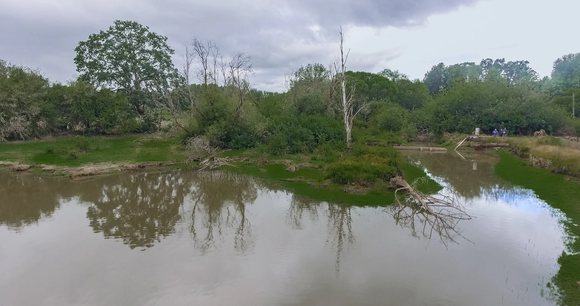
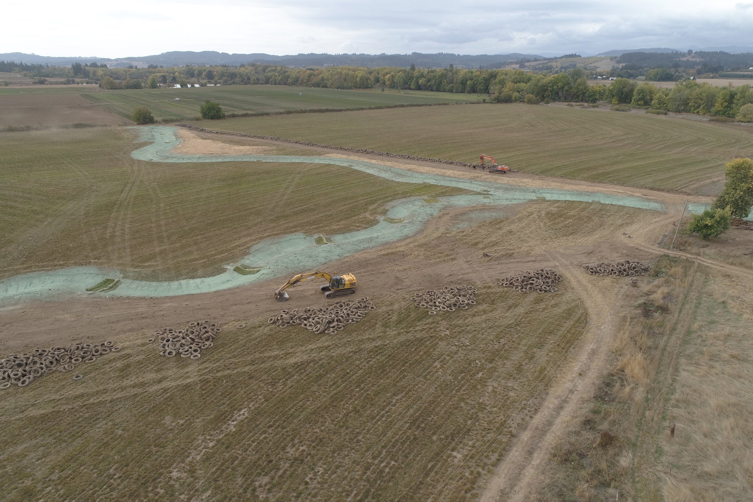
Five creeks (Harris, Fern Hill, Wapato, Scoggins, and an unnamed tributary) touch the site, as does the main stem of the Tualatin. For decades, much of the creek water within Spring Hill’s northern parcel disappeared underground into a drainage system that made agricultural activities more efficient. In the summer of 2018, after removing a small dam, contaminated soil that disconnected wetlands, and roughly 4,000 semi-truck tires that had served as the makeshift drainage system, crews created more natural flow paths for two seasonal creeks and placed large wood to improve stream and wetland functions. Cattle grazing continues at the site, as does farming of tall fescue, clover and wheat.
Today, Spring Hill Natural Area functions as both productive working land and a showcase of ecological enhancement strategies.


The Site
First planting: 2018
Size: 246 acres
Stream length: 1.4 miles
Plant communities: Riparian Forest, Shrub and Emergent Wetlands, Prairie
The Challenge
Doing ecological enhancement at sites after decades of heavy human use always presents challenges. Here, as is common, partners encountered invasive plants, sparse riparian vegetation, and ditched and tiled creeks.
The unique element that members of Spring Hill’s project team will always remember involved the drainage system. It’s not unusual to find drain tiles at agricultural sites, typically made out of perforated pipe. Here, however, partners found long lines of buried semi-truck tires, arranged like beads on a string.
Prior to the project’s launch, the team knew that this repurposed-tire drainage system was in place in two locations on the property. When excavators got to work, to their surprise, they found double lines of tires in each location—in all, approximately 4,000 tires.
It wasn’t easy to find a tire disposal service with the capacity to handle such a large quantity of big tires responsibly. Ultimately, about half of the project budget went to disposal—not only the tires, but also soil contaminated with hydrocarbons and pesticides, and debris from the small dam, or weir, at the farm pond.
The Transformation
In 2015, Metro purchased the property and began the process of removing several structures: a house, two outbuildings and a silo. An attractive and historic Dutch gambrel barn survived.
The following year, the project team—including staff from Metro and Clean Water Services, as well as contractors—continued the multiyear process of preparing a site for revegetation as they began to develop the ecological enhancement plan.
By the summer of 2018, the team was ready to break ground and take advantage of the in-water work window, the dry season from mid-July to September, when it’s possible to complete construction projects that involve stream and wetland work. At Spring Hill, these activities included removing the buried tires, contaminated soil, and the farm pond dam; excavating meandering creek channels; and installing native sedge/rush mats and large woody debris in those channels to slow and clean the water while creating habitat. Revegetation of the newly constructed channels began with the application of hydroseed mix embedded with native grass and wildflower seed, followed soon by installation of thousands of bare-root native shrubs.
Now, for the first time in decades, two creeks at Spring Hill travel aboveground, following slow and curving channels on their way to the Tualatin River. As the river swells, it meets a reconnected floodplain free of impediments. Conditions are in place for the return of the rare prairie habitat believed to have been present at the site centuries ago, along with shrub and emergent wetlands and riparian forest.
With the big construction push behind them—and the mountain of tires finally gone—partners continue vegetation management, site monitoring and adjustment. Active coordination with the holders of the farming and grazing leases continues. As beavers return to the site and native plantings take root and grow, Spring Hill Natural Area joins the expanding network of successful large-scale landscape restoration efforts in the Tualatin River Watershed.
Key Partners